Anyone got this running yet? It's telling me it's incompatible with 5 different Android devices (Galaxy S5, HTC One, Galaxy Tab, etc etc)
Looks very neat, especially with the GPS Import Feature, but as usual, the delivery already seems to be flawed...
Works fine on an iPad air. It's MUCH better then the old one. Very flexible with track design.
might dig out an old ipad tonight then and play with it... how's the gps integration work? any way to hack the files to just input data without actually driving the route?
Not sure about the GPS data, but it will open a GPX/KML file which you can apparently output from a GPS(?).
You don't really need it though with existing tracks, you can just import a track map and draw over that (I just did the old Bridgehampton Race Circuit in about 10 min!) and I have already done Riverside (I made it a bit big though). You can only do that as a flat track though. If you want elevation changes you will have to do a lot more freehand and get lucky with one of the other (hilly) track building areas.
Copying over a track created on the flat areas should not be too bad. The map shows the length of all the straights and the angles of the corners so just writing those down would make re-creating them pretty straight forward. Getting the elevation changes right or even close will take a bit of luck though (entirely dependent on what is in the area of the map you are building on) .
OH WOW. Time to download me some GT6 updates.
Does anybody use a Mychron 4 with GPS? I wonder if you can upload and build a track that way.
Looks like you could get a track out of Google maps route if you want:
How to plan a route in Google Maps and export it to Gpx / your phone
I wonder how accurate it would be. Not sure it works though, some are saying it doesn't.
I'll donate whatever I have to for someone to get the tail of the dragon mapped in 
We need to do the Kancamagus Highway (rt 112 between Lincoln and Conway New Hampshire) That would make a great point to point race
I was fooling around with the Layout thing in google and I am not sure I understand how to do it. Here is a link to what I think is the file that can be converted to a GPX file.
Air if you can some how convert this to a track it would be an intresting point to point race.
https://www.google.com/maps/d/edit?mid=zPWKV34TReJc.kpqy_3uLn-OE&usp=sharing
I have been using images off the web of a track layout, I am having a problem with scaling, my tracks come out at 6.8 miles, when they should be 3< miles. Regardless it is awesome.
Good news everyone. You do not need to send a Friend request in order to download someones track.
https://www.gtplanet.net/forum/threads/downloading-others-tracks-without-fr.335172/
Yes, scaling is a bit of a pain. It's pretty easy to draw them to big. If you know the dimensions of the track though (e.g. length of a straight) you should be able to get very close using the feedback when drawing. It would be nice if there was an overall scaling feature (as well as the ability to copy a track to a different environment).
It looks like the GPX files are just a collection of points. Not terrible, but it does mean you would still have to radius all the corners. It would eliminate the issue with figuring out the scale though. I would like to see a GPX file that works though because looking at the GPX output of the Conway route (which I drove at least 3 times when I visited there) I suspect you could just isolate the trk and trkseg (track and track segment?) tagged parts and import those.
Placeholder. Here is the Google route for the Tail of the Dragon:
https://www.google.com/maps/d/viewer?mid=zecBDuLzR1Do.kPnjVLLfNvU4&hl=en_US
Nick (Not-Stig) Comstock wrote:
I'll donate whatever I have to for someone to get the tail of the dragon mapped in
Go to arcade mode, then time trial. There is a new category for user made tracks with 4 sample tracks. Do the last one that's a point to point track. It's very Dragon-like!!!
Quick tip:
To get the scale correct, take a picture of the track in google maps (if it still exists) with the scale showing, then scale the picture when you bring it in by matching the scale to the one on screen (home straight can be located in any orientation). Interestingly, turn 1 of the Circuit of the Americas is TOO tight to be modeled!!
In a similar vein, when you create a custom track, zoom in a bit (500-1000 ft scale) or you will tend to make very large tracks. The Circuit of the Americas track required a zoom to the 500 ft scale.
Another tip:
Tight Corners: Narrower track will allow tighter corners (because of the mandatory guard rails). You can also get much tighter corners when you first drag out the corner then if you try to modify it or change the angle thing.
Also:
UPLOAD TRACKS AS YOU MAKE THEM. My app is not allowing me to upload and needs to be re-installed (another iPad works) so I need to re-make 3 tracks!

Rufledt
UltraDork
10/1/15 11:43 p.m.
this is a thing?! i might have to dust off my PS3 at some point!
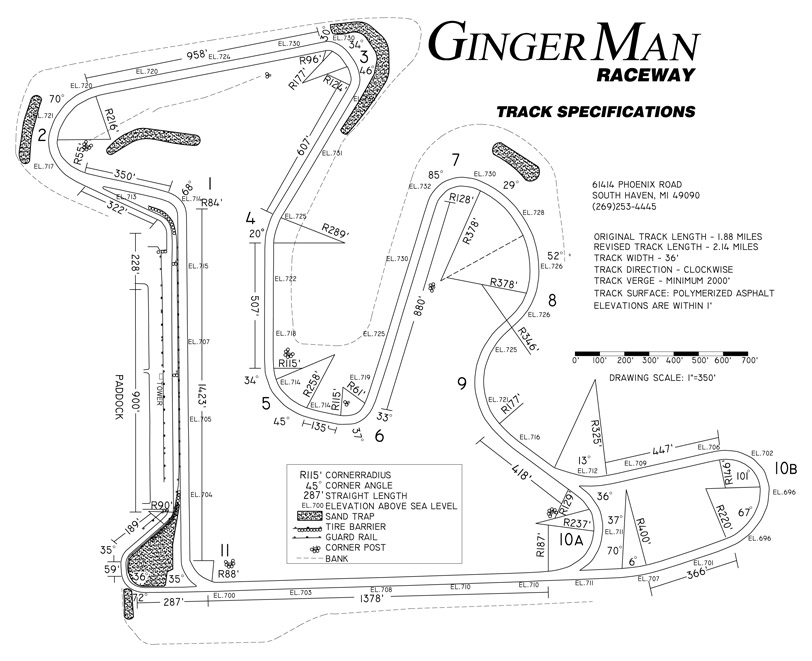
1000 internets to anyone who can map out Gingerman Raceway for me. (This looks way to complicated for my old brain)

That should be very easy. It looks flat also, so it should be pretty representative. I will see what I can do. Those types of tracks are the easiest / best types to do. The only concern there is that the front straight needs to be a minimum length (600m I think).
Any idea how wide the track is? Looks pretty narrow.
still waiting for the internet at home to be fixed so I can see if my tablet will let me use this app.
aircooled wrote:
That should be very easy. It looks flat also, so it should be pretty representative. I will see what I can do. Those types of tracks are the easiest / best types to do.
Any idea how wide the track is? Looks pretty narrow.
According to the track map here: 36 feet. Also, if you can adjust surface type, it was just repaved this summer. The only turn that is really banked significantly is turn 2.
BTW - You the man! I might just raise the contract price to 2,500 internets.
wow with all those dimensions it should be a piece of cake to map that.
I tried to make NCM, but a couple of the corners are too tight to make, even on the most narrow track settings. Booooooo
However I did use the google map scaling method that Air suggested and that's much closer to the true size.
The only minor issue I see is the minimum length of the front straight is 500m, which is 1640 feet. Looks like the real one is 1423, so it will need to be scaled up slightly (about 15%).
The dimensions on the track map BTW are almost exactly how they are shown in the app!
Actually, the longest "straight" is 10b to 11, its just has a slight crest and a bit of a kink on the 10b end of it.


