


aircooled wrote: Jumping uphill always results in a nose down landing, jumping downhill always results in a back flip!. So, I suggest staying with uphill jumps.
HorseE36 M3. Bonus points for landing a backflip.

aircooled wrote: Jumping uphill always results in a nose down landing, jumping downhill always results in a back flip!. So, I suggest staying with uphill jumps.
HorseE36 M3. Bonus points for landing a backflip.

In reply to aircooled:
Okay, got some time to do back to back testing and I definitely think the Dragon V1 is more correct than V2. There are very few actual straight bits of road there, v2 straightened out some of the sections that V1 has.
Thank you to allaircooled! I can't wait to try Gingerman out.

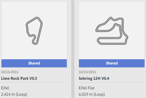
I am sharing some track someone else made: A version of Sebring that is supposed to be pretty good, and Lime Rock, which may not be that good because it looks like the real track has some good elevation changes.

Anyone else having trouble importing KML or GPX files? I created several different KML files in google earth pro that will not import, i used a couple different free online conversion tools to change them to GPX and those wont import. I tried a know, good GPX file from someone at GTplanet and it will not import.
It would appear that I am SOL. Samsung Galaxy Tab Pro 10.1 I think is what we have at home.
I have not tried it, but my suggestion would have been find one that works and make sure the format is the same, but you have done that already. Sounds like it might be an OS issue.
If you can post a link to the file you tried, I can try and test it on an iPad. You have to do some weird file import through iTunes I believe.
I was doing some more reading, it sounds like it could be the google file browser on the device causing the issue. I will download another file management app and try again.
Aw yiss. Got my console updated this morning and have 2 tracks up.
One is a scaled up version of the Summit Point Kart track. Great for cars and also the very fast GT6 karts. The track ran best with minimal banking it is smooth and technical.
I tested my to scale dominion raceway and I made it too narrow. Will be remaking that one
I have 3 courses up now, and a 4th going up this morning.
Little River Gorge Rd - real road in Smoky Mtn National Park, point to point. It runs along a creek in the park so its relatively flat in real life as well.
Summit Point Kart - Scaled up Summit Point Kart track. Technical and fun.
Dominion Raceway - This one is done now. It is the correct scale and approximately the correct orientation on the map as well.
Tequila Worm - Fictional desert course, featuring a "whole mess" of decreasing and increasing radius turns snaking through the gorgeous desert landscape. I had first made this twisty desert course around 2.5 miles, but I thought it was so fun I did a save as and added another couple miles to it. Great for lower PP cars.
https://www.gran-turismo.com/us/gt6/user/#!/friend/retrohoon/course/
Its great that we can bring in images and maps to trace, but the Eifel layouts visually are so frickin boring. I really like Andalusia and LOVE the Desert environments.
A suggestion I have for moving a traced course to a map with elevation:
Trace the track using the overlay method on the flat track BUT only do a very basic version of the track. What you want is simple angles and lengths, do not try to create the track in detail (e.g. straighten out squiggly parts. What you want to end up with is a list of corner angles and lengths and straight lengths, you can even just create a list of them when you are done.
Then you can take that list (or go back and forth between the two maps) and transfer it to a terrain map. THEN you refer to an actual map of the track and add the detail (you will probably have to insert corners etc.)
Things to be careful of:
Make sure you get the corner correct (exit angle is what you are concentrating on) with one swipe. You cannot correct the corner or it will add those complicated dual angles which are almost impossible to replicate.
Undo is a HUGE thing here. If you don't get the corner right, hit Undo (the left arrow icon on the upper tool bar) to start over.
Straights can be a pain. A normal straight segment will not necessarily come straight off the last segment! You will have to watch the previous corner and it's "original shadow" to try to not modify the previous corner (mostly and issue when you go to re-create it).
Still a lot of work (especially with tracks with more subtle angles and curves) and essential a matter of luck getting the terrain right. I did a Bridgehampton version on terrain and ended up with WAY to much elevation change, but it is a fairly simple basic design so re-creating it was not too bad. I tried Riverside on the desert landscape and missed horribly (half way through the track was pointing a very wrong direction). My big mistake though I think was trying to put some of the subtle snaking and esses in the track. I should have just made them straight and modified it later.
Give it a shot, let me know what you think and any ideas / improvements you have.
BTW - if you have any tracks that you need a good scale marker on (to match up to the one on the screen when you import the trace map in) let me know, I can do that pretty easy on any track that has any good evidence of it left in Google maps (e.g. Bridgehampton only had one straight left, but that was enough to get a good scale).
You'll need to log in to post.


